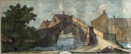
A photo of a print I have in my possession gives some indication as to how the merging water courses at the Trinity Bridge would have looked in circa 1726. The print is by one Samuel Buck who visited various places in the country to do etchings which were later engraved and retailed to various bodies etc.
The article’s author gives an informative view, both written and pictorially, but I feel the then water course would have been a lot less straight; more meandering and narrow, but’s that just my viewpoint.
Some months ago I took early retirement from my employment of nearly 40 years with Anglian Water. My job entailed maintaining waste water treatment plants and the associated infra-structure and one issue which periodically arose in Crowland was ground water infiltration into the sewerage system which can and does cause extra problems.
On one occasion specific tests were carried out under certain conditions to try and ascertain where exactly this water was originating from. In short it was concluded that there was a possibility that the legacy of the once waterways were contributing to the matter even allowing for culverting of conduits, to which the author intimates.
I would be interested to hear any further comments.
19 Wardentree Lane
Pinchbeck
