Reader in medieval archaeology, University of Cambridge
Twitter: @DrSueOosthuizen
I am interested generally in the medieval fenland, what it looked like and what it was like to travel around it.
The marvellous fenland survey by Peter Hayes and Tom Lane (http://eaareports.org.uk/publication/report55/) showed that Crowland Abbey had diverted the River Welland to run almost past its front door – an amazing feat.
Two screenshots from it show how the Roman river flowed to the west of the present town, but that the medieval river ran right through it. They interpreted this as a deliberate diversion of the river by the abbey, and that conclusion is well accepted.
It’s clear, standing on the triangular (Trinity) bridge, that the unusual width of the street leading northwards from the bridge, and the houses lining it, preserve that medieval landscape on either side of the old course of the Welland (a relic of which, I believe, still runs in a conduit under the road). The street had to be that wide to accommodate both the width of a major river and the quays on either side. The work by Hayes and Lane confirms that.
And in one’s mind’s eye, as one stands on the bridge, the river flows again, boats travel up and down it, offloading and loading from the quays, those goods making their way to and from the houses and warehouses that stood along it.
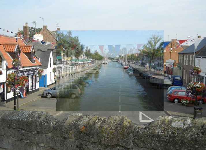
A year or two ago I went to Harlingen in Friesland in North Holland and saw the view from the top of the bridge across the canal there. It links the town with the coast, and boats still ply up and down it.
And you can see the landscape is just the same – the river framed by wide pavements for loading and offloading, and lined with houses and warehouses –only in this case the river is still part of a living landscape. So for fun I just overlaid my Dutch photograph on my Crowland photograph to see what would happen, and got this terrific result.
The point is really the interest and excitement of landscape history. The clues are readily available all around us – we just have to open our eyes to them.
Once one knows that the river once ran through the centre of Crowland, the geography of the layout of the modern street becomes obvious, and superimposing the photographs just brings that knowledge to life.